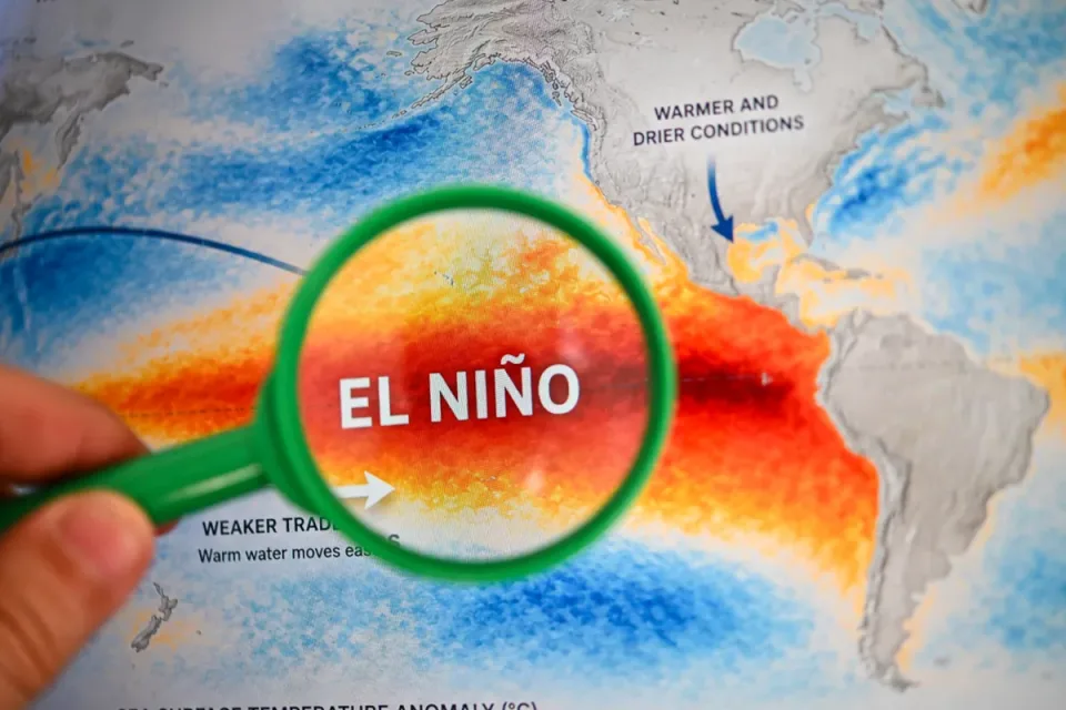
A rapidly intensifying El Niño in the equatorial Pacific Ocean is on track to become one of the strongest such events in at least 150 years of record-keeping, according to forecast models released in the first week of August 2026 by NOAA, the World Meteorological Organization (WMO), and several independent climate research groups. The event, officially declared by NOAA on June 11, 2026, has already crossed the threshold for what forecasters informally call a "super El Niño" and is developing faster than the benchmark 1997-1998 episode.
The headline numbers
Behind the intense global attention lies a set of striking probability figures that climate scientists, governments, humanitarian agencies, and financial markets are parsing with unusual urgency:
97 percent: the probability, according to NOAA's Climate Prediction Center (CPC), that El Niño conditions will persist through early Northern Hemisphere spring 2027.
81 percent: the chance NOAA assigns to a "very strong" event (Relative Oceanic Niño Index of at least 2.0°C) during the October-December 2026 quarter.
Greater than 90 percent: the probability estimated by AccuWeather that the event will reach "super El Niño" status by the end of the Atlantic hurricane season.
Roughly 77 percent: the chance, using NOAA's updated RONI measurement, that this will be the strongest El Niño on record, according to an analysis by Yale Climate Connections.
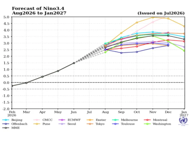
3.6°C (6.5°F) above normal: the median peak anomaly forecast for the Niño 3.4 region across 667 model simulations compiled by Berkeley Earth climate scientist Zeke Hausfather, which would exceed the 2015-2016 record by approximately 0.8°C.
"For context, the gap between the strongest and the fifth strongest El Niño of the past 150 years is only about 0.5°C. The models are forecasting something outside the envelope of anything we have ever observed," Hausfather wrote in his analysis published on July 13, 2026.
What is El Niño, and why is this one different?
El Niño is the warm phase of the El Niño-Southern Oscillation (ENSO), a naturally recurring climate pattern in which sea-surface temperatures in the central and eastern equatorial Pacific rise above their long-term average. This redistribution of ocean heat alters atmospheric circulation, shifting rainfall, storm tracks, and temperature patterns across much of the planet. The phenomenon typically occurs every two to seven years and lasts nine to twelve months.
What distinguishes the 2026 event, according to multiple analyses reviewed for this article, is the combination of its speed of intensification, its projected peak strength, and the global conditions into which it is arriving.
First, the event is intensifying at a pace that surpasses the 1997-1998 "super El Niño," which had been the gold standard for explosive development. According to Hausfather's comparison of Niño 3.4 anomaly trajectories, the 2026 event is running ahead of 1997 at the same point in the calendar year. Second, unlike the 2015-2016 event, which began from already-warm ocean conditions, this El Niño launched from genuine La Niña conditions in January 2026. "It had a bit of work to do before it even got going," the Wired magazine analysis noted on July 24, 2026.
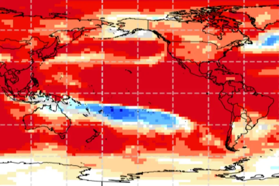
Third, the event is unfolding against a background of global ocean temperatures that are already at record levels. Global sea-surface temperatures have been at record highs for at least two consecutive months, according to CNN reporting on August 4, 2026. This means the El Niño warming is being superimposed on an ocean that is already historically hot, amplifying its capacity to drive extreme weather.
Why the world is watching: four reasons this El Niño has grabbed global attention
1. The model agreement is extraordinary
It is highly unusual for all major computer models used to predict El Niño to agree on a strong-to-record event persisting through winter and potentially well into 2027. "Typically, some models deviate and predict a waning event at some point, or a switch into La Niña," Jeffrey Shaman, a climate and public health researcher at Columbia University, told CNN during an El Niño media briefing in late July 2026. "But not this time. It is just an El Niño as far ahead as the projections go."
The ECMWF ensemble, one of the most trusted modeling systems, shows every single ensemble member exceeding the 2.0°C threshold by September, with the model average peaking above 3.0°C. This level of inter-model consensus gives forecasters unusually high confidence months ahead of the expected peak.
2. The world is already broiling
The El Niño is intensifying in a year that has already shattered multiple temperature records. South Korea recorded 108.5°F (42.5°C) on a Sunday in early August, its highest temperature in history. Western Europe experienced its hottest June on record, with France logging its hottest day ever. Barcelona hit 105.3°F (40.7°C), an all-time high. In the United States, Salt Lake City reached 109°F (42.8°C), also a record. Massive wildfires in France forced more than 200,000 people to evacuate, in what French President Emmanuel Macron called the worst fire-related crisis since World War II, according to Yale Environment 360.
At the United Nations on Friday, August 1, 2026, Secretary-General António Guterres declared: "El Niño is not just on our doorstep. It is inside the house and turning up the heat. And this is only a warm-up act. El Niño is strengthening, adding fuel to a planet already on fire with scorching heat domes, apocalyptic wildfires and record hot seas."
3. It could push global temperatures past critical thresholds
El Niño events release vast amounts of stored ocean heat into the atmosphere, temporarily boosting global average surface temperatures. Because the 2026 event is forecast to be so strong and to last well into 2027, climate scientists now project that 2027 could reach approximately 1.7°C above the preindustrial average, according to Hausfather's projections published in Wired. This would represent the largest single-year excursion above the 1.5°C threshold that the Paris Agreement identified as a dangerous warming limit.
A separate analysis by Carbon Brief showed that the odds of 2026 setting an annual global heat record rose from 19 percent in April to 35 percent by July. For 2027, scientists say a new record is "a near lock."
4. The subsurface engine is enormous
Beneath the ocean surface, in the top 500 meters (1,640 feet) of the equatorial Pacific, a massive pool of anomalously warm water, known as a downwelling Kelvin wave, has been building since June 2026. According to meteorologist Andrej Flis, writing on the Severe Weather Europe platform on August 6, 2026, subsurface temperature anomalies are now peaking at more than 8°C above normal. This reservoir of heat is the real engine of the event, and as it rises to the surface in the coming months it will continue to feed the surface warming.
"This reveals the deep core of this Super El Niño event: a strong, warm anomaly that is now peaking over 8 degrees above normal," Flis wrote. "This is significant for any El Niño event, but especially when we consider that we have only just entered August, with the peak anomaly still months away."
The probability landscape: what the models actually say
To answer the question of how likely a "serious" outcome is, it helps to disentangle what different probability figures refer to. The most commonly cited numbers describe the likelihood that the event will reach a certain measured strength, not the likelihood of specific impacts. A stronger El Niño raises the probability of typical El Niño impacts occurring but does not guarantee them, and it does not mechanically determine their severity.
Source | Probability | What it measures | Date issued |
|---|---|---|---|
NOAA CPC | 97% | El Niño persists through early spring 2027 | August 3, 2026 |
NOAA CPC | 81% | "Very strong" event (RONI ≥2.0°C) in Oct-Dec 2026 | August 3, 2026 |
NOAA CPC | 90% | RONI ≥1.5°C during Aug-Oct 2026 | August 3, 2026 |
AccuWeather | >90% | "Super El Niño" by end of hurricane season | August 3, 2026 |
Yale Climate Connections / Berkeley Earth | ~77% | Strongest El Niño on record (RONI-based) | July 14, 2026 |
Polymarket (prediction market) | 88% | "Super El Niño" during winter 2026-27 | August 4, 2026 |
Carbon Brief | 35% | 2026 becomes warmest year on record globally | July 2026 |
It is worth noting that NOAA changed its official measurement scale in February 2026. The new Relative Oceanic Niño Index (RONI) removes the background warming of the global tropics, making it possible to compare the strength of El Niño events across different decades on a like-for-like basis. Under the older ONI scale, the forecast peak reaches approximately 3.6°C. Under the newer RONI, it is closer to 2.5°C. Both figures describe the same physical event; they are simply different yardsticks. News reports that quote one without the other can create confusion.

The Indian Ocean Dipole: a second engine joins the first
Complicating the outlook further, a positive Indian Ocean Dipole (IOD) is now developing alongside the El Niño. The IOD is a climate pattern in which the western Indian Ocean becomes warmer than average while the eastern part cools. A positive IOD typically strengthens rainfall over eastern Africa and parts of India while drying out Indonesia and Australia.
The WMO confirmed on July 31, 2026, that a positive IOD is forecast to develop during the August-October period. "Together, these oceanic drivers can amplify regional climate impacts including drought, floods and wildfire risk, particularly around the Indian Ocean basin," the agency stated.
Meteorologist Andrej Flis of Severe Weather Europe described the combined effect as "a fully connected, dual-ocean atmospheric system" in which rising air over both the central Pacific and the western Indian Ocean launches atmospheric wave trains that simultaneously alter the jet stream over North America and Europe. Historically, a positive IOD during an El Niño amplifies drought risk in Australia and Indonesia while intensifying rainfall in East Africa. Australia's Bureau of Meteorology noted that one of the strongest positive IOD events on record was a key driver of the catastrophic 2019-2020 bushfire season.
Regional impacts: who gets drought, who gets flood
The WMO's Global Seasonal Climate Update for August-October 2026 paints a map of sharp precipitation contrasts, consistent with a classic strong El Niño:
Regions likely to be wetter than normal
The Greater Horn of Africa (increased flood risk)
Parts of Central Asia and the northern Arabian Peninsula
Southern Europe
Western North America south of 45°N (including California)
Southeastern South America (flooding risk highlighted in southeast Brazil)
The central and eastern equatorial Pacific
Regions likely to be drier than normal
The Indian subcontinent (weaker monsoon, already running about 20 percent below average through mid-July)
Southern and eastern Australia
Southern Central America and parts of the Caribbean
Northwestern and northern coastal South America
Northern Europe
Indonesia, the Philippines, and Papua New Guinea
In the United States, the winter 2026-2027 outlook from the ECMWF model shows a classic El Niño split-flow pattern: a strong high-pressure ridge over Canada keeping the northern tier mild and relatively dry, while an active southern storm track brings wetter, potentially stormier conditions from California across Texas, the Gulf Coast, and the Southeast. The European Centre model gives California a greater than 90 percent probability of above-normal precipitation from December through February, with coastal regions potentially receiving 50 percent more precipitation than normal. However, climate scientist Daniel Swain cautioned in Bay Nature magazine on August 6, 2026, that "just because one strong El Niño event did not yield a wet winter absolutely does not mean that this one will not be wet."
For the Atlantic hurricane season, El Niño is expected to continue suppressing activity. On August 6, 2026, NOAA maintained its prediction for a below-normal season, citing strong wind shear over the tropical Atlantic generated by the El Niño circulation. Colorado State University's August outlook called for just 9 named storms, 4 hurricanes, and 1 major hurricane, well below the seasonal average of 14 named storms, 7 hurricanes, and 3 major hurricanes.
Food security and the hunger forecast
Perhaps the most consequential probability concerns global food security. On August 5, 2026, the World Food Programme (WFP) released an analysis warning that the developing El Niño could push approximately 50 million additional people into acute hunger before the end of 2027. This would represent a 22 percent increase over the 225 million people in 45 countries already classified as acutely food insecure.
Central America, the Caribbean, and southern Africa are expected to be hardest hit. In southern Africa, the main growing season runs from October 2026 to March 2027, but the worst hunger impacts are expected during the lean season roughly nine months after harvest, in late 2027 and early 2028.
"The biggest food security impact, in southern Africa, will be during the 2027 to 2028 lean season," Richard Choularton, WFP director of climate and resilience service, told The Guardian.
The WFP has budgeted at least $80 million for anticipatory relief efforts, but Choularton noted that efforts were being hampered by a lack of data as some collection programs had been cut for lack of funding. Jean-Martin Bauer, WFP director of food security, warned that the impact on food prices would extend well beyond the 45 most vulnerable countries. "It is very important to avoid a situation where large countries stop food exports," Bauer said.
The UN Food and Agriculture Organization (FAO) separately warned on August 5, 2026, that the combination of the Iran conflict, the Ukraine war, the strengthening El Niño, higher oil prices, and tightening supplies of agricultural inputs could trigger another wave of global food inflation before the end of 2026. Commodity price increases typically take three to six months to reach consumers, suggesting food inflation could intensify through 2027. Analysts at Allspring Global Investments noted that "El Niño is just going to make inflation more sticky," according to the China Daily.
The economic toll: a potential $10 trillion event
A study by Justin Mankin, a climate scientist at Dartmouth College, found that the 1997-1998 El Niño caused approximately $5.7 trillion in cumulative global economic losses in the years that followed, through extreme weather damage, agricultural output losses, and supply chain disruption. If the current forecasts are accurate, Mankin told multiple outlets, including Wired and USA Today, that the 2026-2027 episode could generate cumulative losses of around $10 trillion by 2032.
These figures, while staggering, come with significant uncertainty. They are based on econometric modeling that links historical El Niño intensity to subsequent GDP reductions, particularly in tropical countries whose economies are most exposed to climate variability. The $10 trillion figure is a scenario estimate, not a prediction, and assumes the event peaks at or near the forecast intensity.
Peru's central bank has already warned that inflation could exceed its target this year. India's monsoon, running roughly 20 percent below normal through mid-July, has raised concern about rice production. In the United States, the American Farm Bureau Federation estimates that farmers growing nine major crops could collectively lose $32 billion in 2027 without additional federal support.
Background: how we arrived at this moment
The 2026 El Niño did not come as a surprise. NOAA and other agencies had been forecasting an El Niño transition since late 2025, following a prolonged La Niña that had persisted through much of 2024 and early 2025. What was less certain was how fast it would strengthen and how intense it would become.
NOAA officially declared the onset of El Niño conditions on June 11, 2026. At the time, the April-June RONI stood at 0.5°C, just at the operational threshold. By the end of July, the weekly Niño 3.4 anomaly had surged to 1.5°C above average (on the relative scale), and the Climate Impact Company reported on August 6, 2026, that the Nino34 SSTA index had reached +2.52°C, crossing the informal "super El Niño" threshold of +2.0°C.
The WMO's multi-model forecast released on July 31, 2026, shows the Niño 3.4 mean rising from 2.7°C in August to 3.1°C in September and 3.4°C in October, with the peak expected in November. The three-month mean for August-October is forecast at 2.9°C above the 1991-2020 average.
Historical analogues offer both cautionary and sobering lessons. The 1876-1878 El Niño, which may have been comparable in magnitude to the current forecasts, triggered catastrophic droughts across China, southern Africa, Brazil, Egypt, and India, contributing to famines that killed millions of people, including more than 6 million in India alone. The 2015-2016 "Godzilla" El Niño caused an estimated 60 to 100 million people to experience acute food insecurity and generated $5.7 trillion in economic losses. The 1997-1998 event produced devastating floods in parts of South America and East Africa while triggering severe drought in Indonesia and Papua New Guinea.
However, the world of 2026 is different from the world of 1876 or even 1997. Early warning systems, satellite monitoring, anticipatory humanitarian action, and climate-resilient agriculture did not exist at scale in earlier eras. The WFP's anticipatory action programs, for example, did not exist during the 2015-2016 event. These capabilities, while unevenly distributed, offer a buffer that previous generations lacked.
Why it matters
The 2026 El Niño matters beyond meteorology because it will function as a stress test for food systems, infrastructure, emergency response, and political stability across multiple continents simultaneously. It arrives at a moment when global food prices are already elevated by the Iran conflict and the aftermath of the Ukraine war, when inflation remains a central concern for central banks, and when public tolerance for price shocks is low.
The event also has direct implications for public health. The World Health Organization has scheduled an EPI-WIN webinar for August 12, 2026, on preparing for El Niño-related health risks, including heat-related illness, waterborne and vector-borne diseases, malnutrition, and mental health impacts. The Pan American Health Organization launched an "El Niño and Health" Community of Practice on August 4, 2026, to coordinate responses across the Americas.
For policymakers, the high confidence in the forecast creates both an opportunity and a dilemma. The advance notice allows for pre-positioning of food aid, adjustments to crop planting, water conservation measures, and public health preparations. But acting on a probabilistic forecast, however confident, requires political will and budgetary commitment that is not always forthcoming. "Some authorities continue to delay decisions despite increasingly strong forecasts, either waiting for additional confirmation or assuming their countries will avoid the worst impacts," the Associated Press reported on July 17, 2026, citing a WMO official.
WMO Secretary-General Celeste Saulo captured this tension directly: "Forecasts in themselves do not prevent hazards, people do. This El Niño developing against the backdrop of unprecedented ocean heat and rising temperatures provides governments and communities with a window of opportunity to anticipate risks and act before impacts unfold. The decisions we make today will shape the impacts we experience tomorrow."
What scientists still cannot tell us: the uncertainty caveats
For all the confidence in the intensity forecast, several important unknowns remain.
Strength does not equal impact. A stronger El Niño raises the probability that typical teleconnections will materialize, but as NOAA's Nathaniel Johnson explained to CNN, "it is also possible that a record strong El Niño means some of the impacts will be larger or stronger than usual too, though that is not guaranteed." The 2015-2016 event, for example, did not deliver the wet California winter that many expected.
Regional variability is high. The WMO explicitly cautions that "not all regions of the world are affected, and even within a region, impacts can be different." The Bay Area in California, for instance, sits outside the zone where El Niño precipitation patterns are most predictable. "We cannot generalize and say El Niño means X for California," climate scientist Daniel Swain told Bay Nature.
Limited historical analogues. Because the forecast peak is outside the range of observed events, models are extrapolating beyond the data on which they were trained. The convergence of model outputs around the 3.6°C mark is reassuring but does not eliminate the possibility that the real-world behavior of the ocean-atmosphere system at such extreme anomalies could differ from model projections.
"Super El Niño" is not an official term. The WMO does not use the term in its operational products, and NOAA uses "very strong" rather than "super." The term is informal and lacks a universally agreed definition, though it is generally understood to mean anomalies above 2.0°C sustained for at least three months. The WMO's official classification uses weak, moderate, strong, or very strong.
The post-peak trajectory is uncertain. While models agree on a strong peak, they diverge on how quickly the event will decay afterward and whether a rapid transition to La Niña could follow. Historically, the five recorded super El Niño events since 1970 were followed by a quick transition into either neutral or La Niña conditions. A rapid flip to La Niña in 2027 would bring its own set of impacts, including a more active Atlantic hurricane season.
What happens next
The immediate timeline is as follows:
August-October 2026: El Niño strengthens into a strong-to-very-strong event. Global temperatures remain elevated. India's monsoon season concludes with likely below-normal rainfall. The Atlantic hurricane season, while below normal overall, enters its climatological peak in early September; even a quiet season can produce a devastating landfall.
November 2026-February 2027: The expected peak intensity window. This is when the strongest teleconnections typically manifest: wet conditions across the southern United States, drier and warmer conditions in the Pacific Northwest and northern tier, drought in Australia and Indonesia, and elevated rainfall in the Horn of Africa and parts of South America.
March-May 2027: El Niño is expected to begin weakening but is likely to persist through early spring, continuing to influence global weather patterns.
Mid-to-late 2027: Global average temperatures are expected to reach their peak for this cycle, potentially hitting 1.7°C above preindustrial levels. Food price inflation that begins in late 2026 is likely to be felt most acutely by consumers during this period.
NOAA's next ENSO Diagnostic Discussion is scheduled for the second week of August 2026. The WMO's full El Niño/La Niña Update, incorporating the Indian Ocean Dipole and Atlantic conditions, is due in early September 2026. Both will be closely parsed for any change in the intensity forecast or the expected duration.
In the meantime, the WMO, WFP, WHO, and national meteorological agencies are urging governments to use the remaining lead time to activate early warning systems, pre-position humanitarian supplies, adjust agricultural planning, and prepare health systems for heatwaves, floods, and potential disease outbreaks. As Columbia University's Jeffrey Shaman put it: "Because of the forecasts and the high certainty, now is really the time to get ready."
Frequently asked questions
What is the difference between El Niño, Super El Niño, and a very strong El Niño?
El Niño refers to any sustained warming of at least 0.5°C above average in the key monitoring region of the equatorial Pacific. A "very strong" event (NOAA's term) is one where the anomaly reaches at least 2.0°C on the RONI scale. "Super El Niño" is an informal term used by some meteorologists to describe anomalies above roughly 2.0°C sustained for at least three months. The WMO does not use the term officially.
How likely is it that this will actually be the strongest El Niño on record?
Using the relative index (RONI), there is roughly a 77 percent chance that the 2026-2027 event will surpass all previously recorded events dating to 1950. Using the older absolute index, the probability is higher because recent decades are warmer overall. Both represent the same physical ocean temperatures; the difference lies in the measurement yardstick.
Does a strong El Niño guarantee extreme weather where I live?
No. El Niño tilts the odds in favor of certain outcomes in certain regions but does not guarantee them. The strength of the event increases the probability that typical El Niño weather patterns will occur, but local outcomes depend on many other factors, including shorter-term weather patterns that cannot be predicted months in advance.
Will this El Niño affect the Atlantic hurricane season?
Yes. El Niño typically increases wind shear over the tropical Atlantic, making it harder for hurricanes to form and intensify. NOAA has maintained a below-normal hurricane season forecast for 2026, and Colorado State University's August update reduced its Texas landfall probability from 27 percent to 13 percent. However, forecasters caution that even a quiet season can produce a devastating storm.
How long will this El Niño last?
NOAA gives a 97 percent probability that El Niño conditions persist through early spring 2027. The Climate Impact Company projects an end time around the middle of 2027. Some models suggest a rapid transition to La Niña could follow, but this is uncertain.